Por favor, use este identificador para citar o enlazar a este item:
http://hdl.handle.net/10261/214606COMPARTIR / EXPORTAR:
|
|
|
| Visualizar otros formatos: MARC | Dublin Core | RDF | ORE | MODS | METS | DIDL | DATACITE | |

| Título: | Seismic Imaging of the Moroccan Atlas (SIMA): a wide-angle reflection profile |
Autor: | Ayarza, P.; Teixell, A.; Carbonell, Ramón CSIC ORCID | Fecha de publicación: | 17-jun-2020 | Editor: | DIGITAL.CSIC | Citación: | Ayarza, P., Teixell, A., and Carbonell, R. (2010). Seismic Imaging of the Moroccan Atlas (SIMA): a wide-angle reflection profile. DIGITAL.CSIC, http://dx.doi.org/10.20350/digitalCSIC/12532 | Resumen: | The crustal structure and topography of the Moho boundary beneath the Atlas Mountains of Morocco has been constrained by a controlled source, wide-angle seismic reflection transect: the SIMA experiment (Seismic Imaging of the Moroccan Atlas). It is a high resolution seismic profile acquired from the Sahara craton across the High and the Middle Atlas and the Rif Mountains. | Descripción: | A high-resolution controlled-source wide-angle reflection seismic experiment was carried out in Morocco in spring 2010. The energy released by six explosions was recorded by 939 Reftek 125a stations (Texans) from the IRIS instrument pool. The location of the shots had an average spacing of 70 km between them. The charge (approximately 1 TM) was distributed in 2–4 boreholes per shot point at depths of 30–60 m. | URI: | http://hdl.handle.net/10261/214606 | DOI: | 10.20350/digitalCSIC/12532 | Referencias: | Ouraini, F., Carbonell, R., Martí, D., Ayarza, P., and Gueraoui, K. (2015). Forward modeling of SIMA seismic line. Contemporary Engineering Sciences, vol. 8, no. 16, 729-736. https://doi.org/10.12988/ces2015.53196 Ayarza, P., R. Carbonell, A. Teixell, I. Palomeras, D. Martí, A. Kchikach, M. Harnafi, A. Levander, J. Gallart, M. L. Arboleya, J. Alcalde, M. Fernandez, M. Charroud, and M. Amrhar (2014), Crustal thickness and velocity structure across the Moroccan Atlas from long offset wide-angle reflection seismic data: The SIMA experiment, Geochem. Geophys. Geosyst., 15, 1698–1717. https://doi.org/10.1002/2013GC005164 Carbonell, R., P. Ayarza, J. Gallart, J. Diaz, M. Harnafi, A. Levander, and A. Teixell (2014), From the Atlas to the Rif a Crustal seismic image across Morocco: The SIMA & RIFSIS control source wide-angle seismic reflection data, paper presented at EGU General Assembly, Eur. Geosci. Union, Vienna, Vol. 16, EGU2014-6303, 2014 Carbonell, R., Gallart, J., Díaz, J., Gil, A., Harnafi, M., Ouraini, F., Ayarza, P., Teixell, A., Arboleya, M. L., Palomeras, I., and Levander, A. (2013). A 700 km long crustal transect across northern Morocco, Geophysical Research Abstracts, vol. 15, EGU2013-8313. |
| Aparece en las colecciones: | (Geo3Bcn) SeisDARE |
Ficheros en este ítem:
| Fichero | Descripción | Tamaño | Formato | |
|---|---|---|---|---|
| Descripcion_ficheros_SIMA_dataset.xlsx | List of the files included in this dataset | 9,34 kB | Microsoft Excel XML | Visualizar/Abrir |
| Readme_SIMA.txt | Dataset general information | 2,34 kB | Text | Visualizar/Abrir |
| Index card_SIMA.pdf | Index card summarizing the main characteristics of the dataset | 3,44 MB | Adobe PDF | 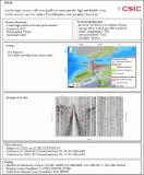 Visualizar/Abrir |
| SIMA-shts.sgy | Shot gathers of the SIMA experiment | 586,06 MB | SEGY | Visualizar/Abrir |
CORE Recommender
Page view(s)
587
checked on 18-abr-2024
Download(s)
285
checked on 18-abr-2024

Google ScholarTM
Check
Altmetric
Altmetric
Este item está licenciado bajo una Licencia Creative Commons
